Hauptseite
Landkarten & Stadtpläne Weltweites
Boden und Geologie
Infos & News
Geschichte &
Zukunft
Bilder und Töne
Spaß & Kurioses
Tools
Karten zum
bearbeiten
Hauptseite >
Landkarten & Stadtplan Index > Weltweites
Kriegskarten / Schlachtpläne
Verzeichnis
Perry-Castaneda
Library Map Collection
Hier finden Sie eine
große Sammlung Kriegskarten und Schlachtpläne aus dem 2. Weltkrieg
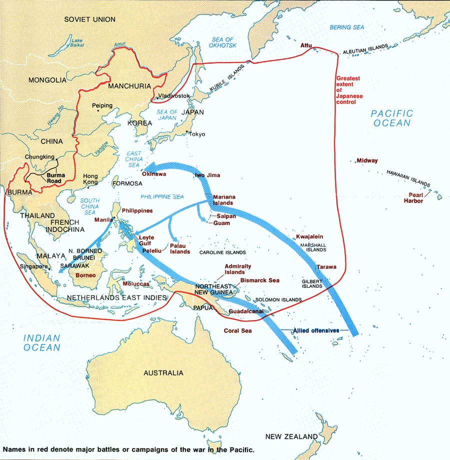
Asiatisch- / Pazifischer Krieg
[Ambon, Netherlands East Indies] - Tan Toey Prisoners of War Camp
1943 "Sketch Map of Tan Toey Prisoners of War Camp, Amboina"
from Allied Geographical Section, Southwest Pacific Area. Area Study
of Ambon Island, Terrain Study No. 45, 13 January 1943. (429K)
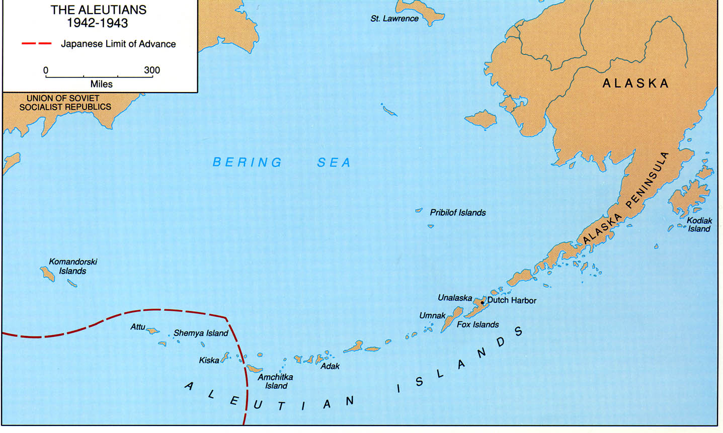
Aleutians, 1942 - 1943 From the Aleutians Islands Campaign
Brochure by George L. MacGarrigle (258K)
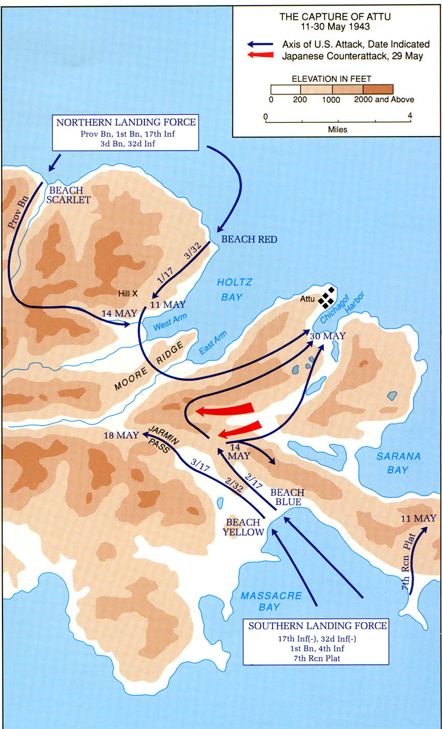
Aleutians - The Capture of Attu, 11 - 30 May 1943 From the
Aleutians Islands Campaign Brochure by George L. MacGarrigle (258K)
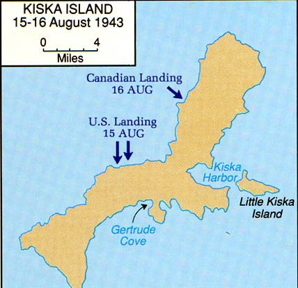
Aleutians - Kiska Island, 15 - 16 August 1943 From the Aleutians
Islands Campaign Brochure by George L. MacGarrigle (65K)
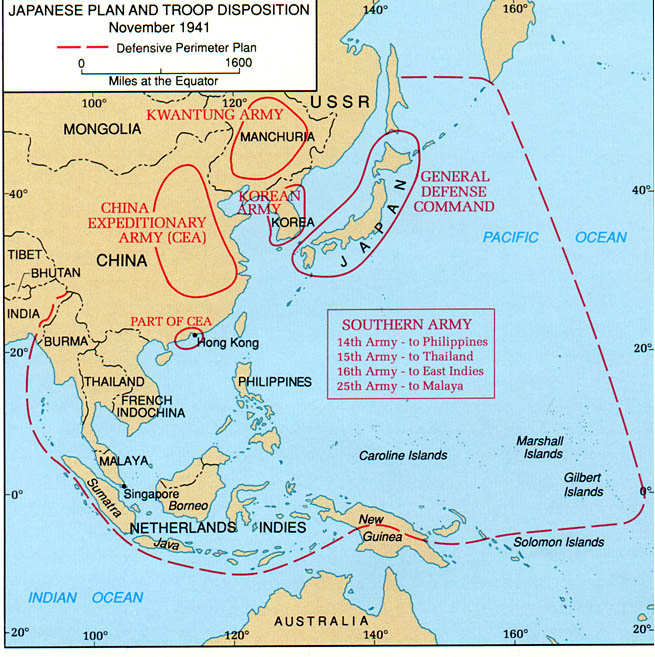
Asia and the Pacific - The Japanese Plan and Troop Disposition,
November 1941 From the Philippines Campaign Brochure by Jennifer
L. Bailey (129K)
[China-Burma-India Theater] Transportation System 1942-1943 From
Stillwell's Mission to China by Charles F. Romanus and Riley
Sunderland [Series: United States Army in World War II:
China-Burma-India Theater]. Dept. of the Army, Office of the Chief
of Military History, 1953.
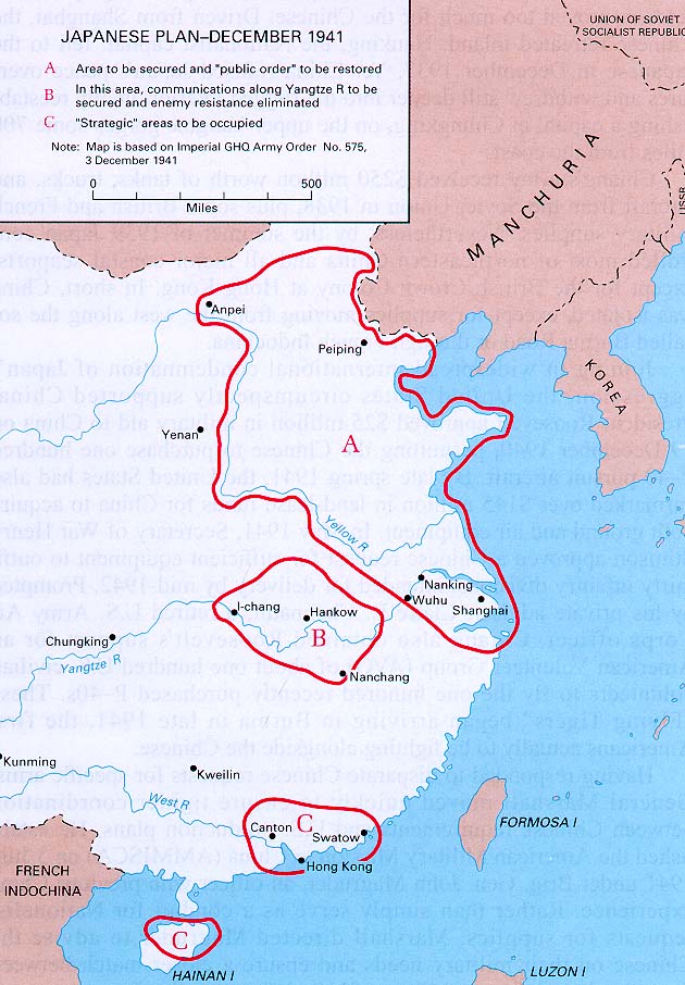
China - The Japanese Plan, 3 December 1941 From the China
Defensive Campaign Brochure by Mark D. Sherry (129K)
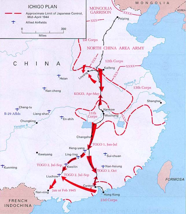
China - Ichigo Plan, April 1944 From the China Defensive
Campaign Brochure by Mark D. Sherry (129K)
China - Salween Campaign, 11 May - June 1944 From the China
Defensive Campaign Brochure by Mark D. Sherry (129K)
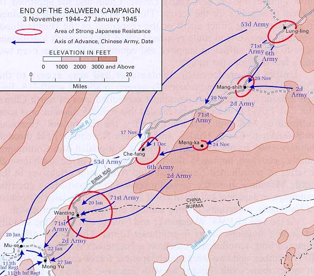
China - End of The Salween Campaign, 3 November 1944 - 27 January
1945 From the China Defensive Campaign Brochure by Mark D.
Sherry (129K)
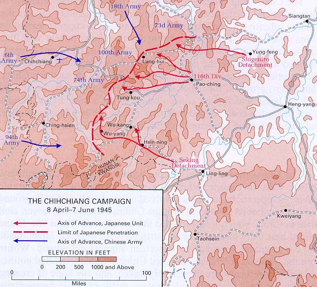
China - Chihchiang Campaign, 8 April - 7 june 1945 From the
China Defensive Campaign Brochure by Mark D. Sherry (129K)
Engineers of the Southwest Pacific, 1941-1945, Vol. 1 Maps of
major Southwest Pacific operations
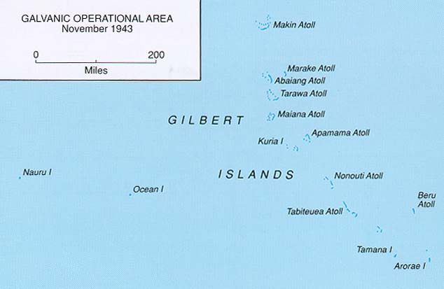
Gilbert Islands - Galvanic Operational Area, November 1943 From
the Central Pacific Campaign Brochure by Lt. Col. Clayton R. Newell
(65K)
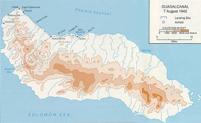
Guadalcanal, 7 August 1942 From the Guadalcanal Campaign
Brochure by Charles R. Anderson (65K)
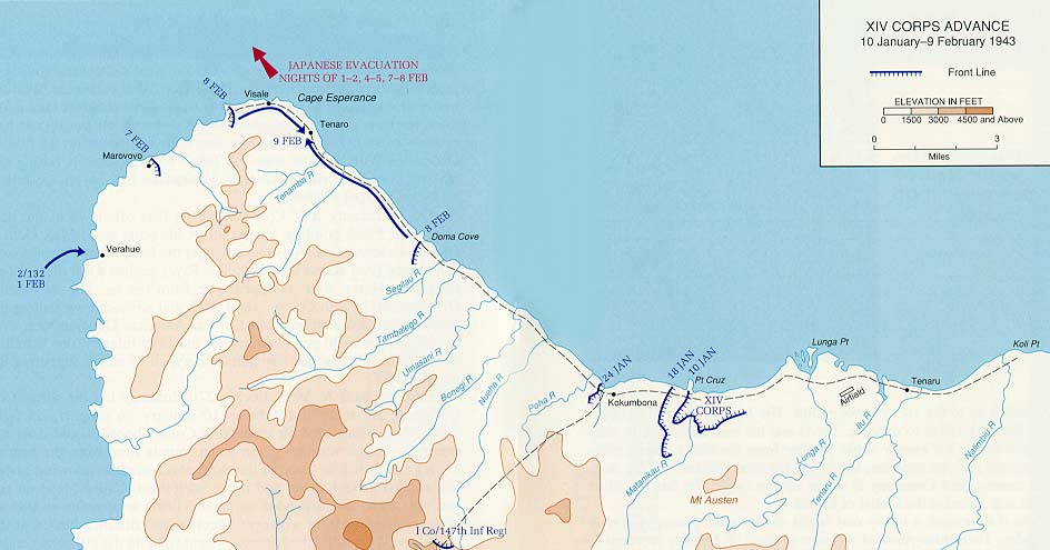
Guadalcanal - XIV Corps Advance, 10 January - 9 February 1943
From the Guadalcanal Campaign Brochure by Charles R. Anderson (129K)
Guam - War In The Pacific National Historical Park Produced by
the U.S. National Park Service 1999 (65K) (PDF Format) and
JPEG Format (61K)
Guam - War In The Pacific National Historical Park (Pacific
Theater 1941-1945) 1999 (110K)
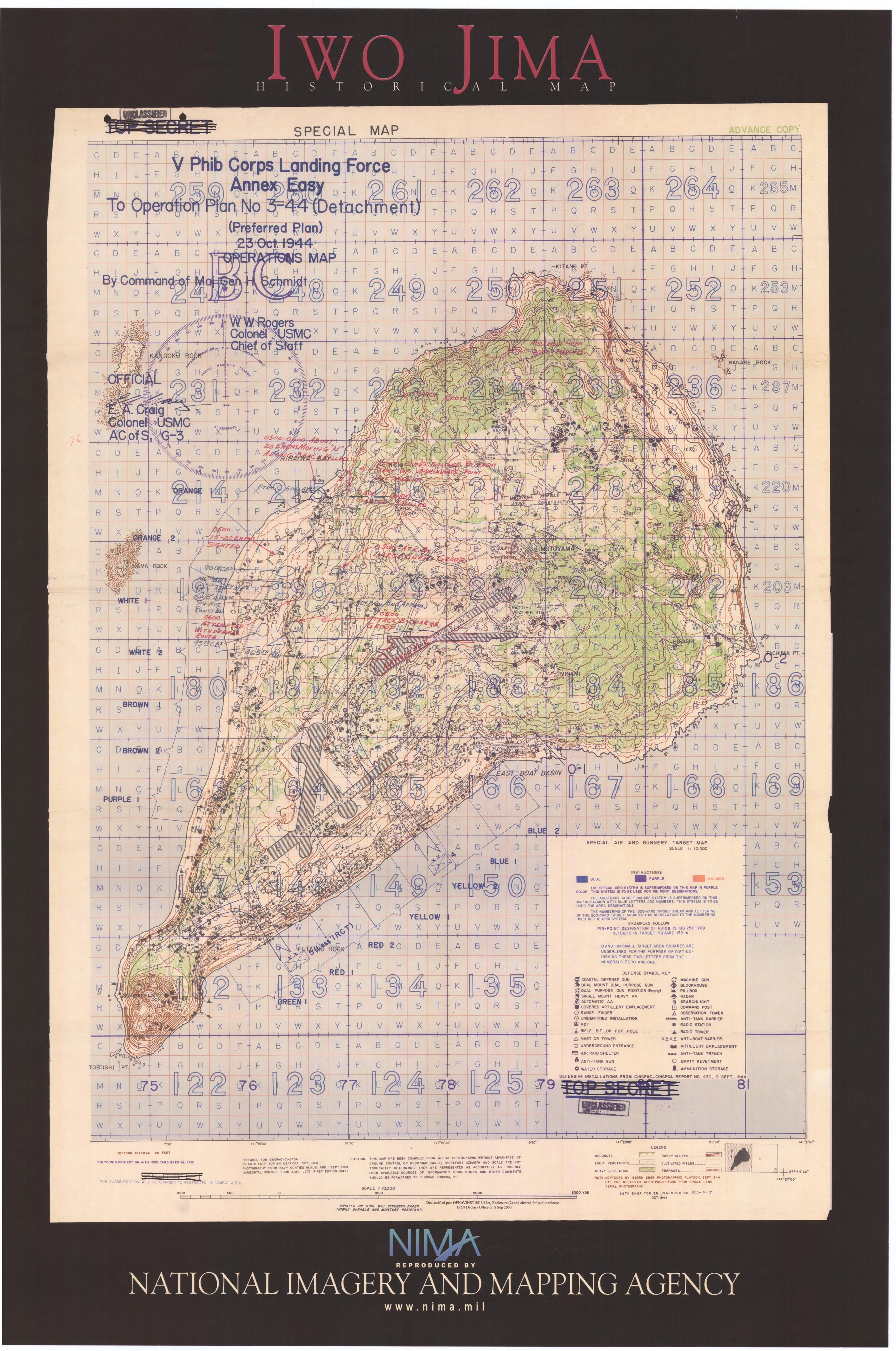
Iwo Jima 1944 "Iwo Jima Historical Map" [poster] National
Imagery and Mapping Agency, 2003 (1.8MB)
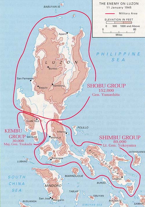
Luzon - The Enemy on Luzon, 11 January 1945 From the Luzon
Campaign Brochure by Dale Andrade (129K)
Luzon - Sixth Army Landings, 9 - 17 January 1945 From the Luzon
Campaign Brochure by Dale Andrade (129K)
Luzon - Troop Dispositions, 21 February 1945 From the Luzon
Campaign Brochure by Dale Andrade (129K)
Luzon - The Capture of Manila, 23 February - 3 March, 1945 From
the Luzon Campaign Brochure by Dale Andrade(129K)
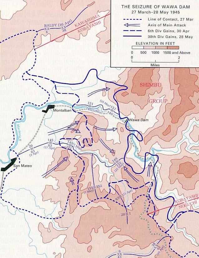
Luzon - The Seizure of Wawa Dam, 27 March - 28 May 1945 From the
Luzon Campaign Brochure by Dale Andrade (194K)
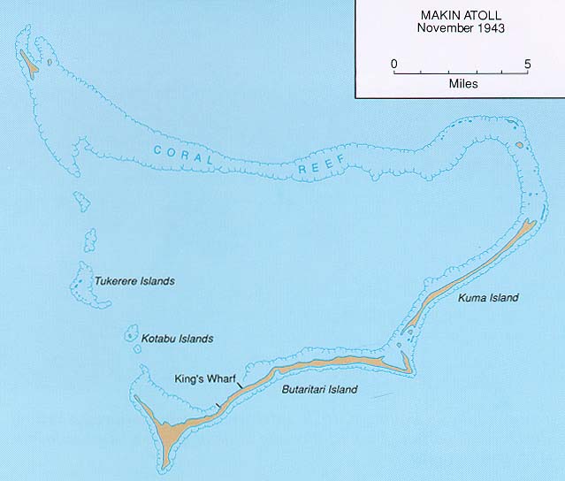
Makin Atoll, November 1943 From the Central Pacific Campaign
Brochure by Lt. Col. Clayton R. Newell (65K)
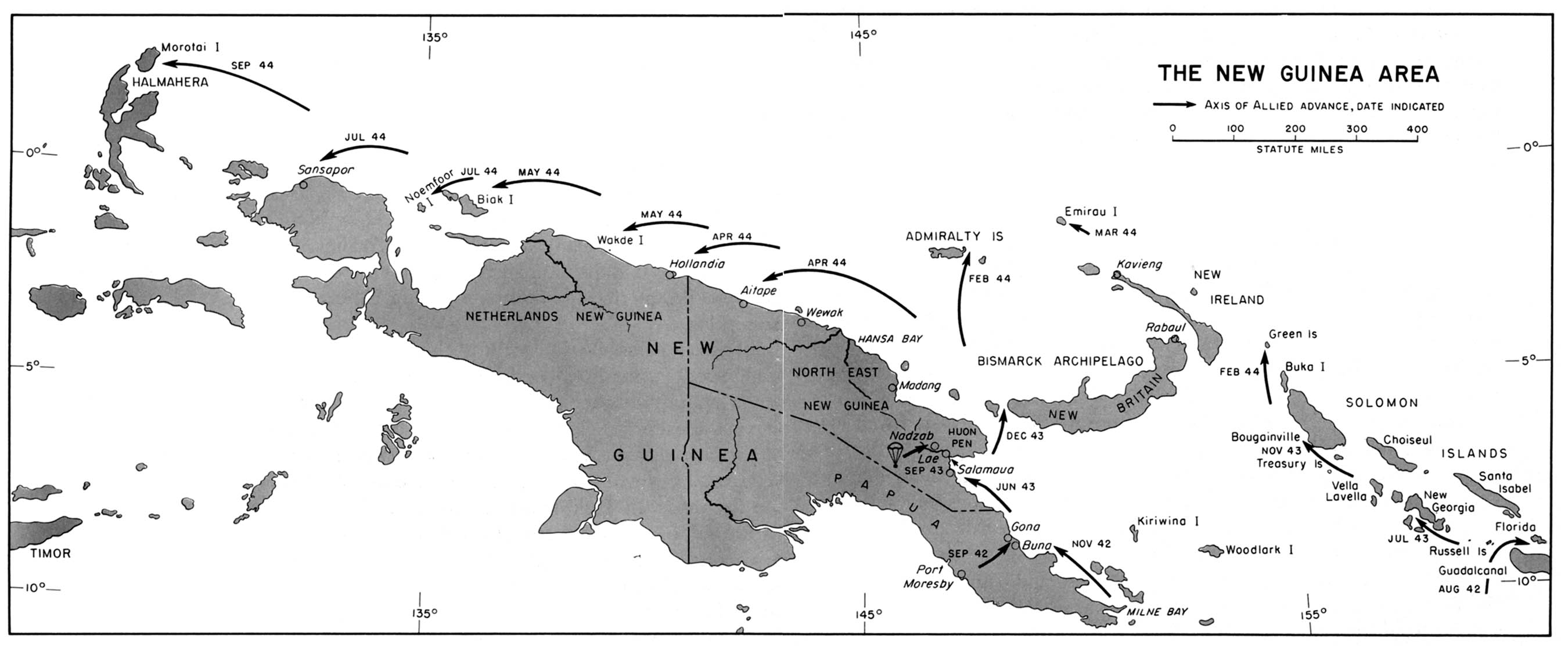
New Guinea Area, 1942-1944 From American Military History,
United States Army Center of Military History, 1989 (194K)
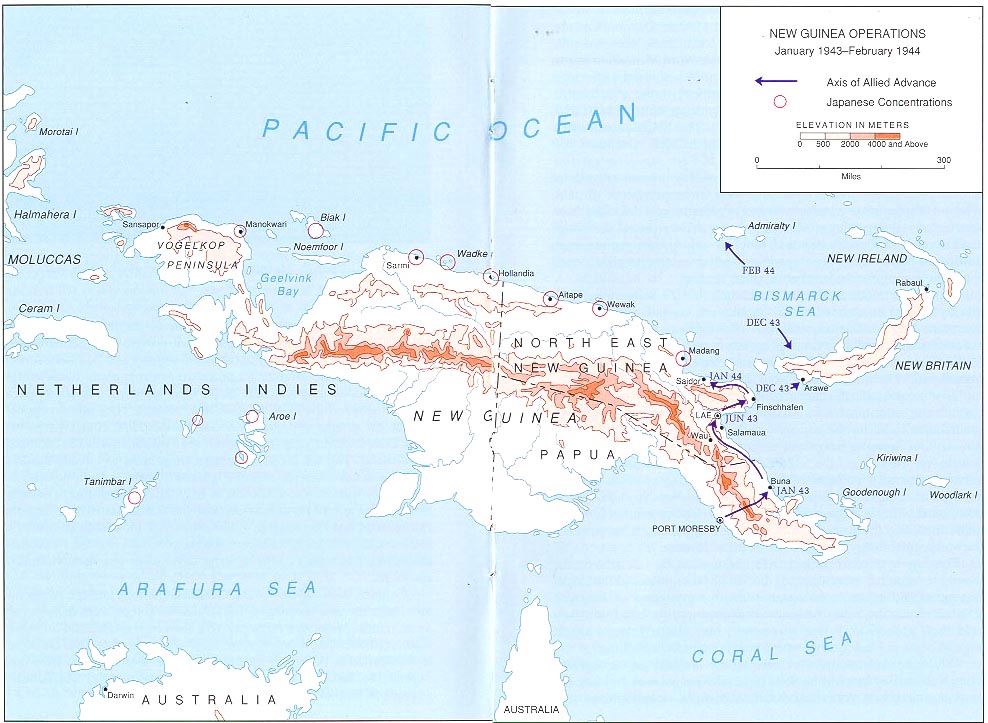
New Guinea Operations, January 1943 - February 1944 From the New
Guinea Campaign Brochure by Edward J. Drea (194K)
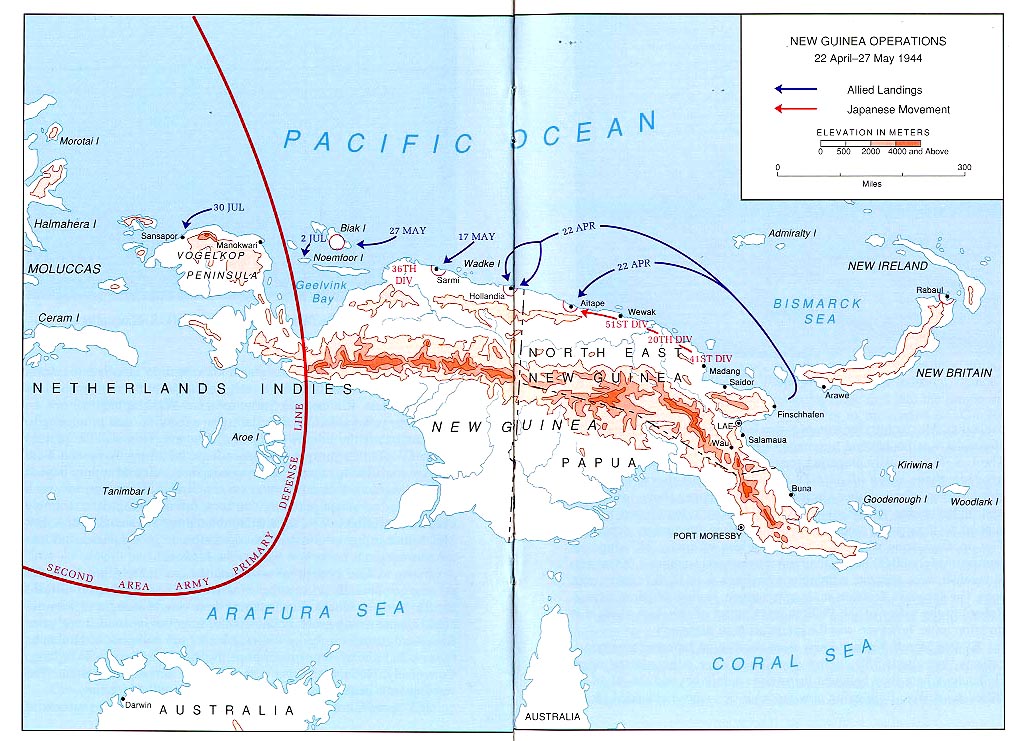
New Guinea Operations, 22 April - 27 May 1944 From the New
Guinea Campaign Brochure by Edward J. Drea (194K)
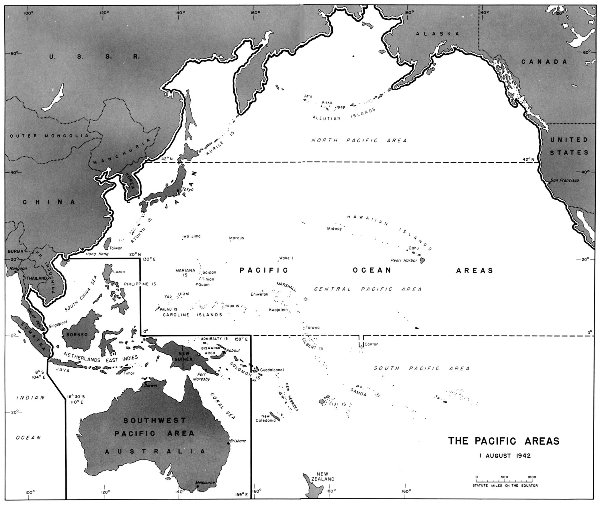
Pacific Areas, 1 August 1942 From American Military History,
United States Army Center of Military History, 1989 (323K)
Pacific Islands [Geographical Handbook Series] 1943-1945 Maps
from Pacific Islands, Great Britain. Admiralty. Naval Intelligence
Division, 1943-1945.
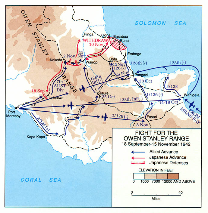
Papua - Fight for The Owen Stanley Range, 18 September - 15 November
1942 From the Papua Campaign Brochure by Charles R. Anderson
(129K)
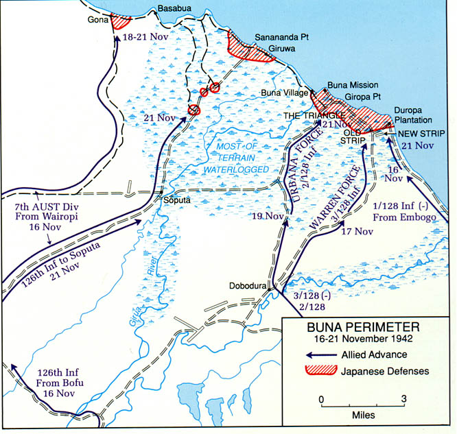
Papua - Buna Perimeter, 16 - 21 November 1942 From the Papua
Campaign Brochure by Charles R. Anderson (194K)
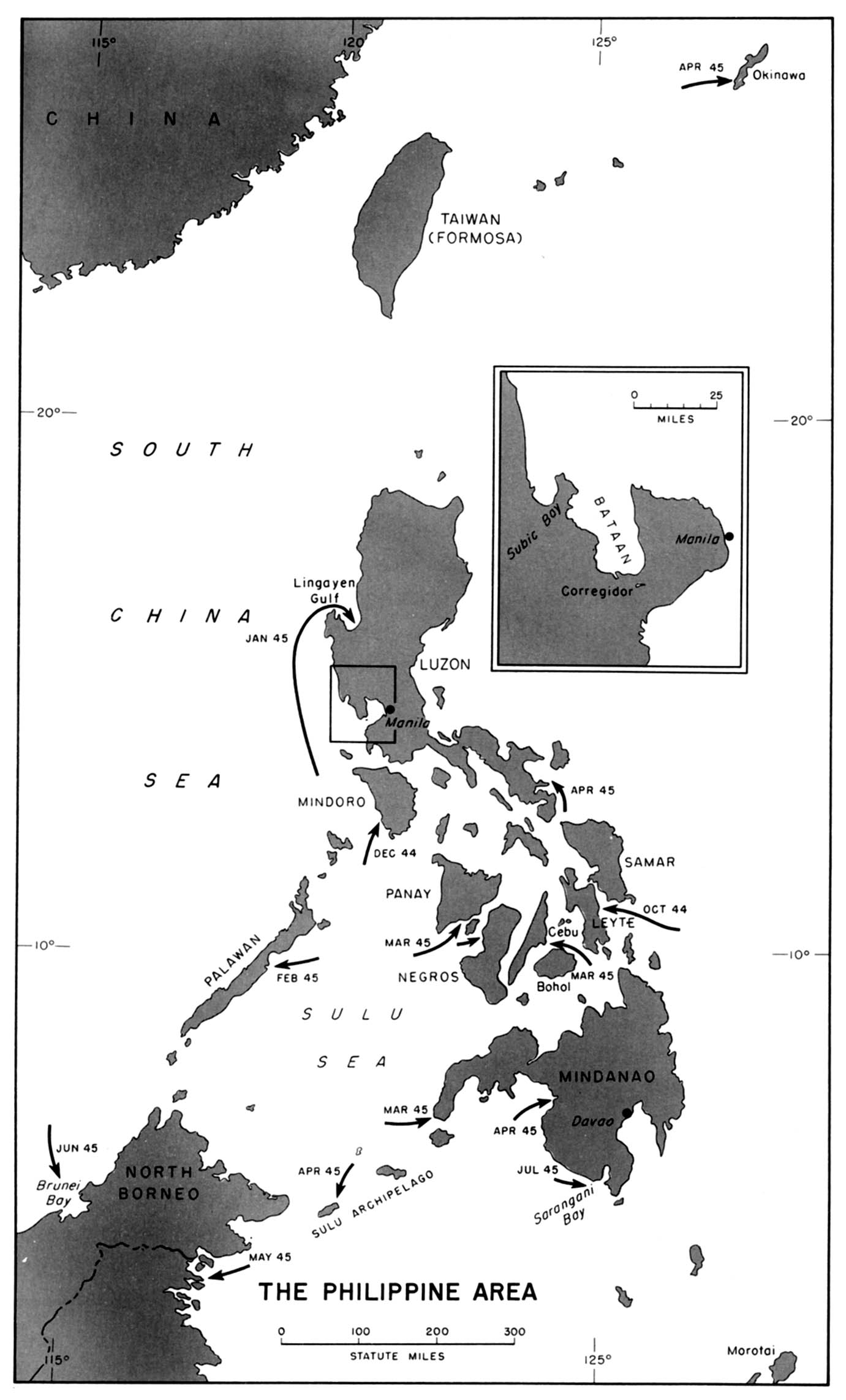
Philippine Area, 1944-1945 From American Military History,
United States Army Center of Military History, 1989(194K)
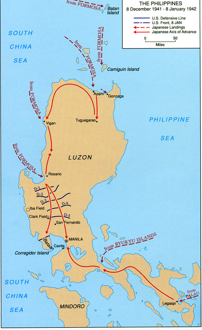
Philippines, 8 January 1942 From the Philippines Campaign
Brochure by Jennifer L. Bailey (194K)
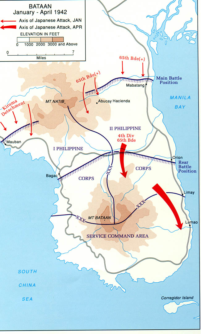
Philippines - Bataan, January - April 1942 From the Philippines
Campaign Brochure by Jennifer L. Bailey (194K)
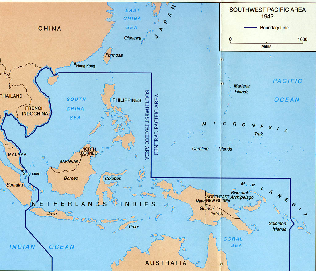
Southwest Pacific Area, 1942 From the Papua Campaign Brochure by
Charles R. Anderson (194K)
Europa im 2. Weltkrieg
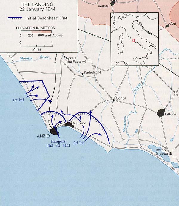
Anzio - The Landing, 22 January 1944 From the Anzio Campaign
Brochure by Clayton D. Laurie (129K)
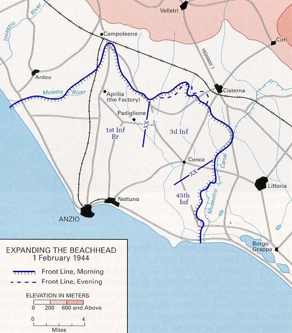
Anzio - Expanding The Beachhead, 1 February 1944 From the Anzio
Campaign Brochure by Clayton D. Laurie (129K)
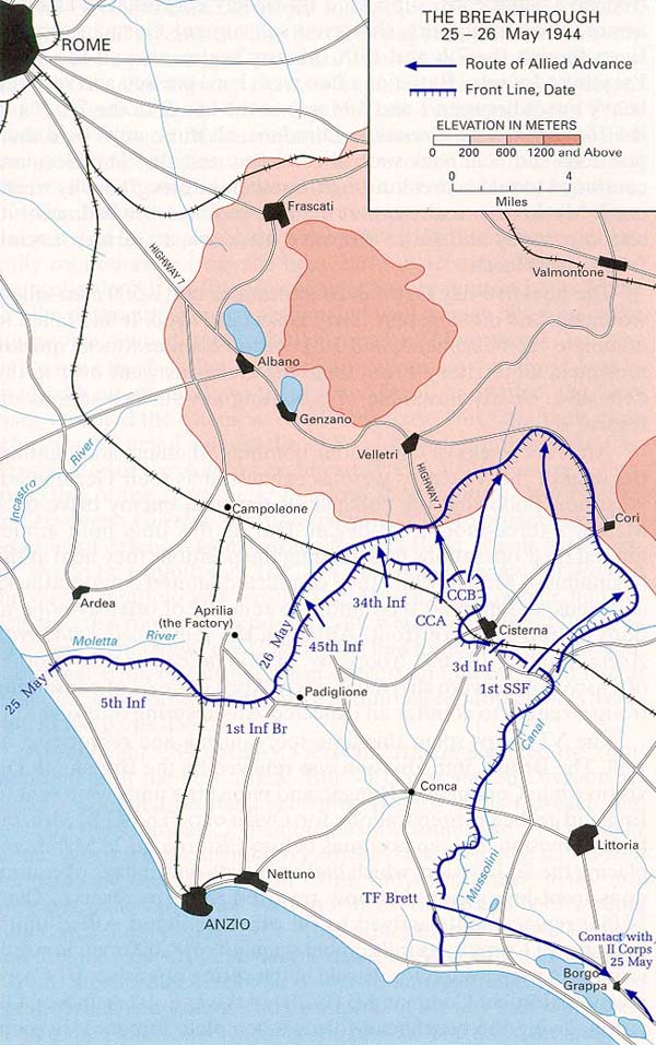
Anzio - The Breakthrough, 25 - 26 May 1944 From the Anzio
Campaign Brochure by Clayton D. Laurie (129K)
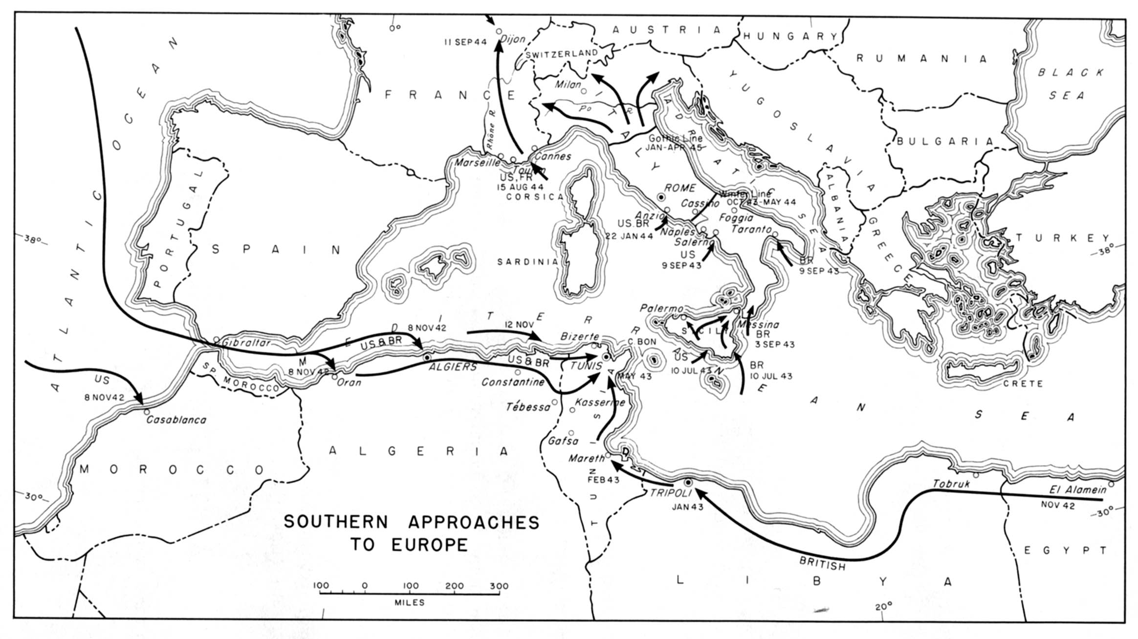
Europe - Southern Approaches to Europe, 1942-1945 From American
Military History, United States Army Center of Military History,
1989(258K)
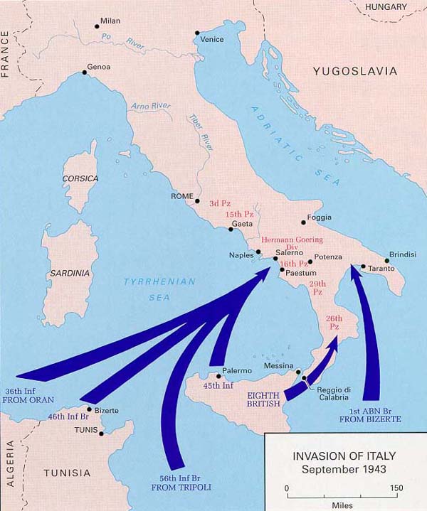
Naples-Foggia - Invasion of Italy, September 1943 From the
Naples-Foggia Campaign Brochure by Col. Kenneth V. Smith (129K)
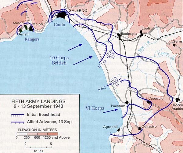
Naples-Foggia - Fifth Army Landings, 9 - 13 September 1943 From
the Naples-Foggia Campaign Brochure by Col. Kenneth V. Smith (194K)
Naples-Foggia - Allied Gains, 6 October - 15 November 1943 From
the Naples-Foggia Campaign Brochure by Col. Kenneth V. Smith (194K)
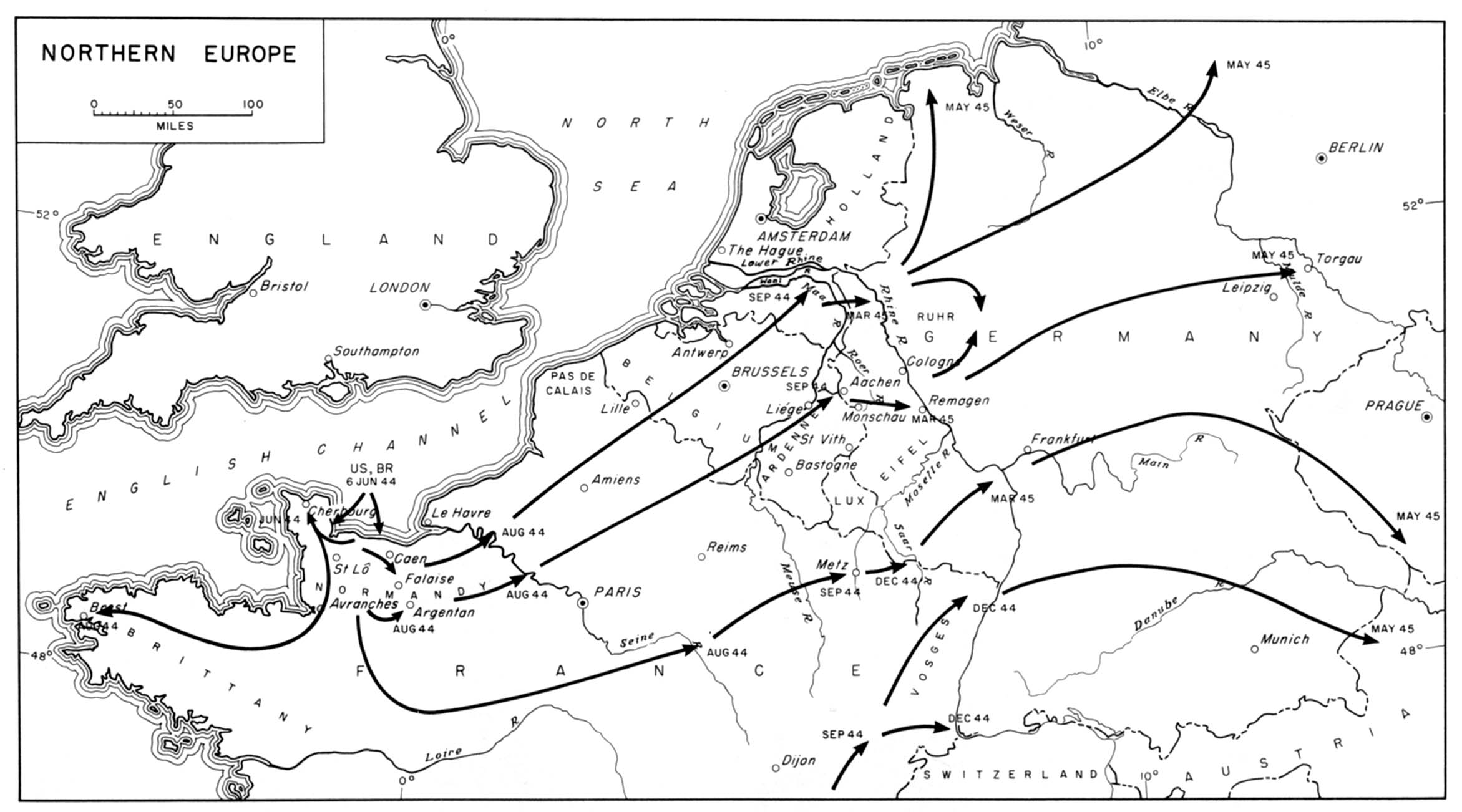
Northern Europe, 1944-1945 From American Military History,
United States Army Center of Military History, 1989 (258K)
D-Day Maps, 6 June 1944 Prepared by the Commander Task
Force 122, April 21, 1944
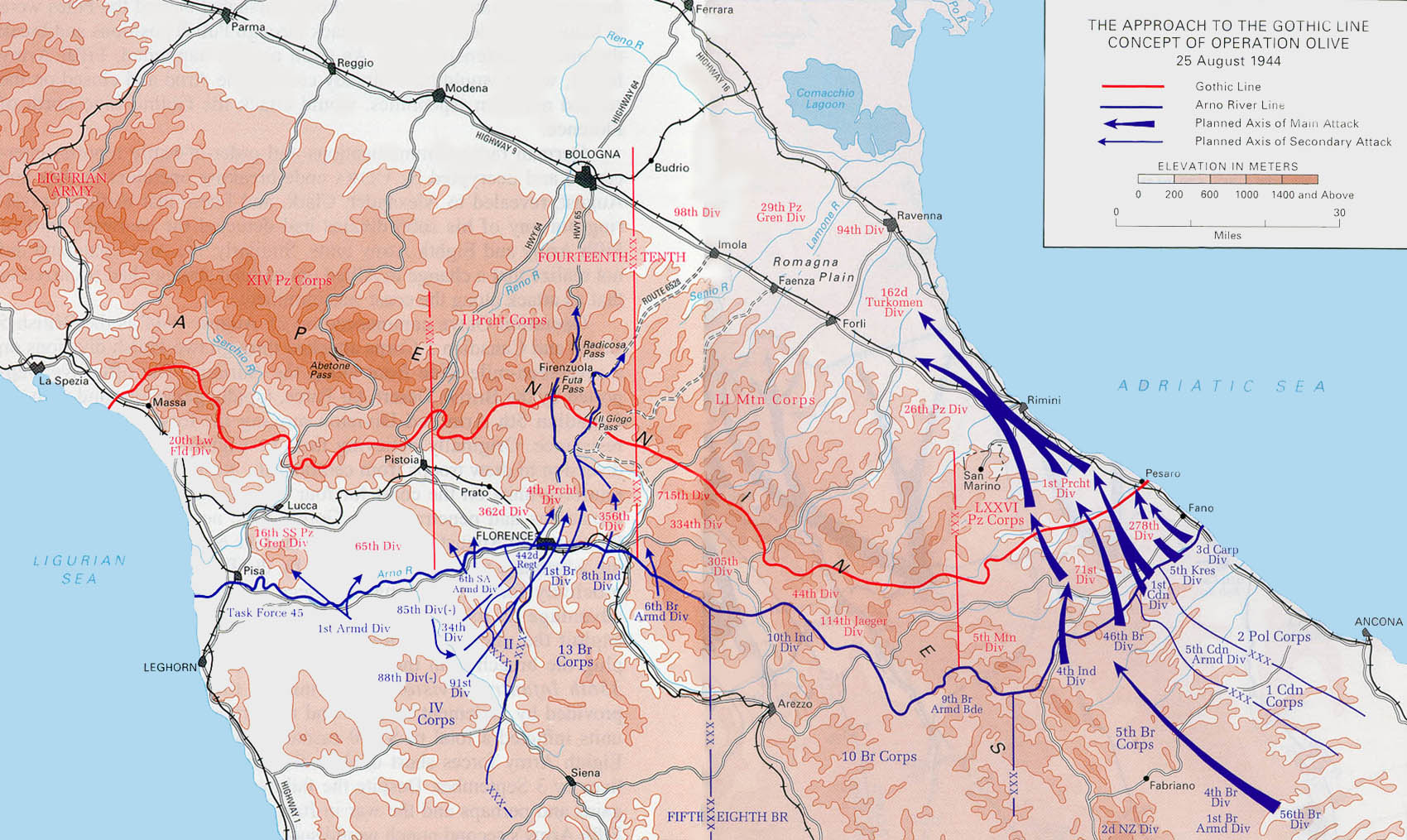
North Apennines - Approach to the Gothic Line / Concept of Operation
Olive, 25 August 1944 From the North Apennines Campaign Brochure
by Dwight D. Oland (387K)
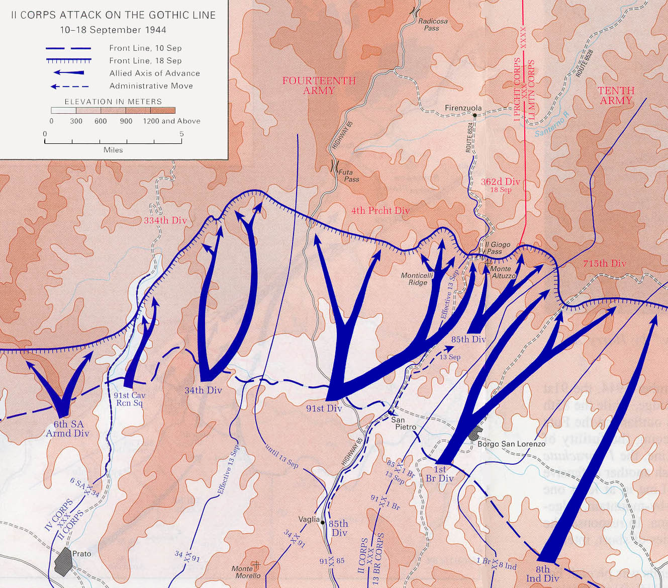
North Apennines - II Corps Attack on the Gothic Line, 10 - 18
September 1944 From the North Apennines Campaign Brochure by
Dwight D. Oland (387K)
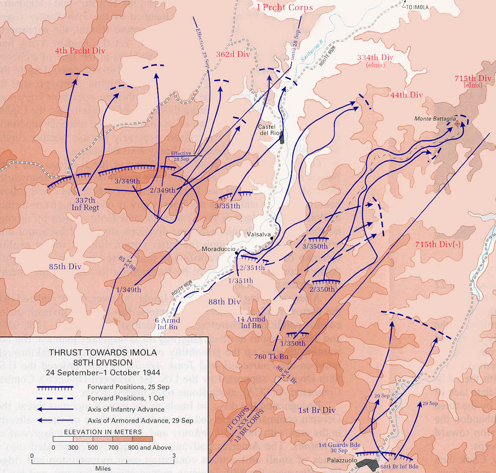
North Apennines - Thrust Towards Imola 88th Division, 24 September -
1 October 1944 From the North Apennines Campaign Brochure by
Dwight D. Oland (323K)
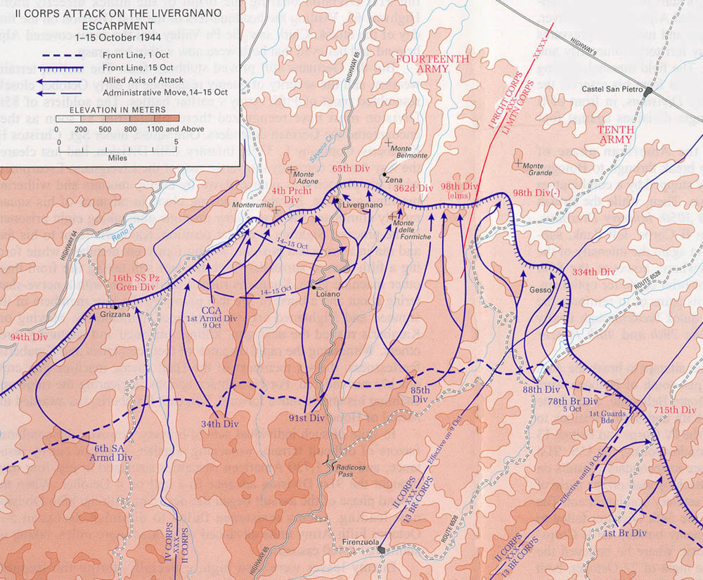
North Apennines - II Corps Attack on the Livergnano, 1 - 15 October
1944 From the North Apennines Campaign Brochure by Dwight D.
Oland (258K)
North Apennines - Operation Encore, 19 February - 5 March 1945
From the North Apennines Campaign Brochure by Dwight D. Oland (129K)
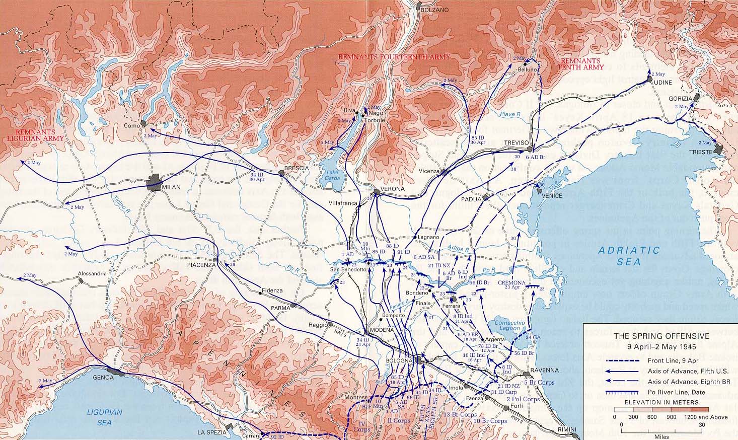
Po Valley - The Spring Offensive, 9 April - 2 May 1945 From the
Po Valley Campaign Brochure by Thomas A. Popa (387K)
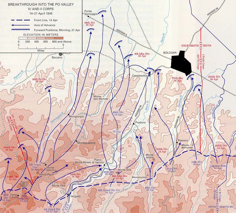
Po Valley - Breakthrough into the Po Valley IV and II Corps, 14 - 21
April 1945 From the Po Valley Campaign Brochure by Thomas A.
Popa (258K)
Rome-Arno - Allied Strategy in Italy, January 1944 From the
Rome-Arno Campaign Brochure by Clayton D. Laurie (129K)
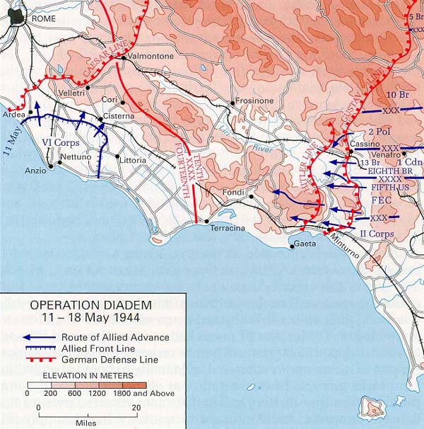
Rome-Arno - Operation Diadem, 11 - 18 May 1944 From the
Rome-Arno Campaign Brochure by Clayton D. Laurie (129K)
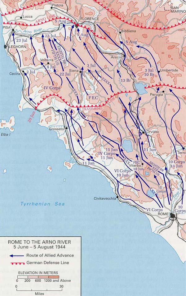
Rome-Arno - Rome to the Arno River, 5 June - 5 August 1944 From
the Rome-Arno Campaign Brochure by Clayton D. Laurie (194K)
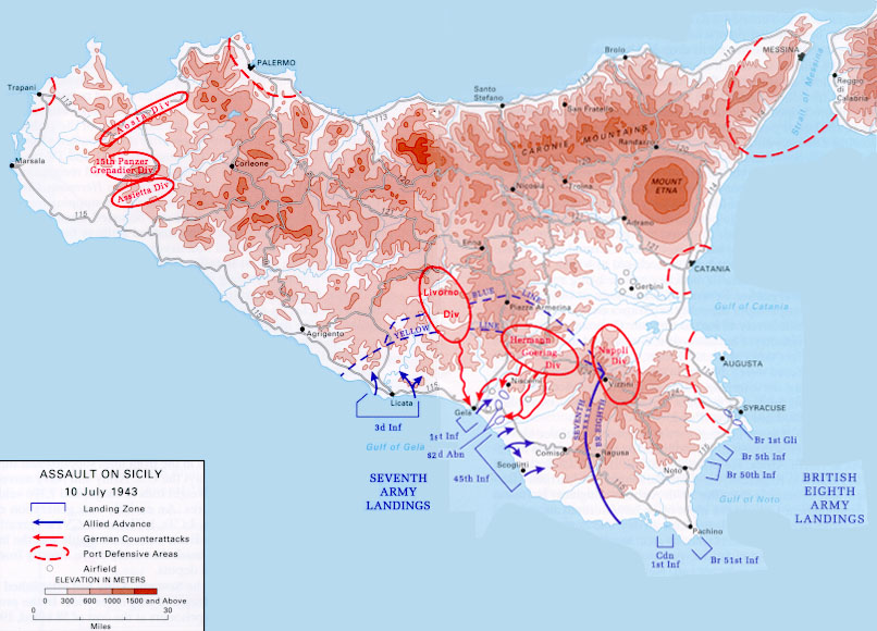
Sicily - Assault on Sicily, 10 July 1943 From the Sicily
Campaign Brochure by Andrew J. Birtle (194K)
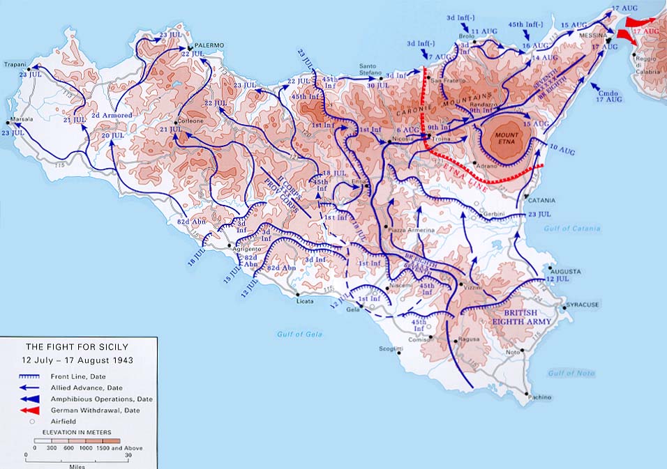
Sicily - The Fight for Sicily, 12 July - 17 August 1943 From the
Sicily Campaign Brochure by Andrew J. Birtle (129K)
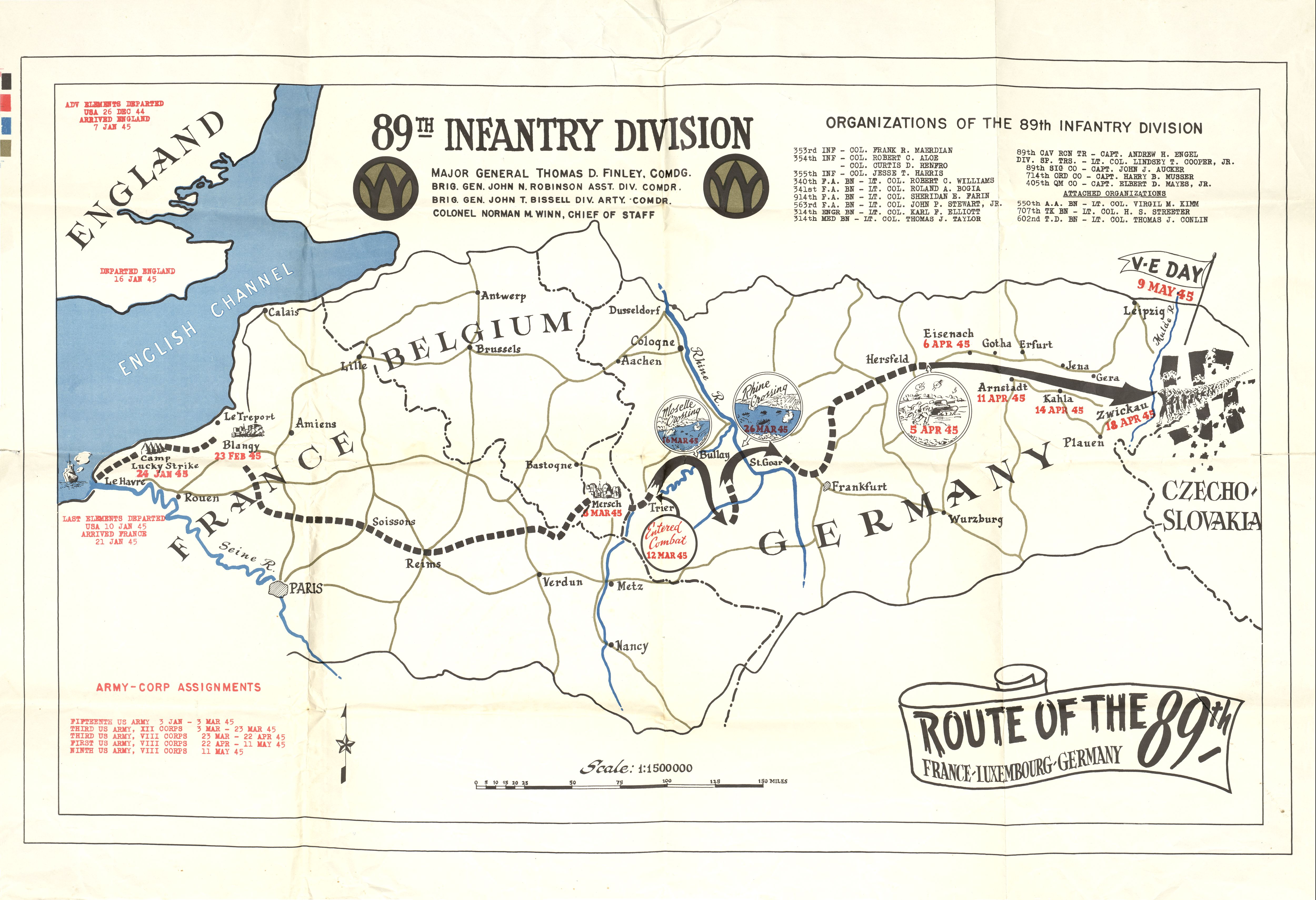
89th Infantry Division - Route of the 89th France, Luxembourg,
Germany 1945 (1.5 MB) Scan of copy from the estate of Dr. Keith
Young, University of Texas Department of Geosciences
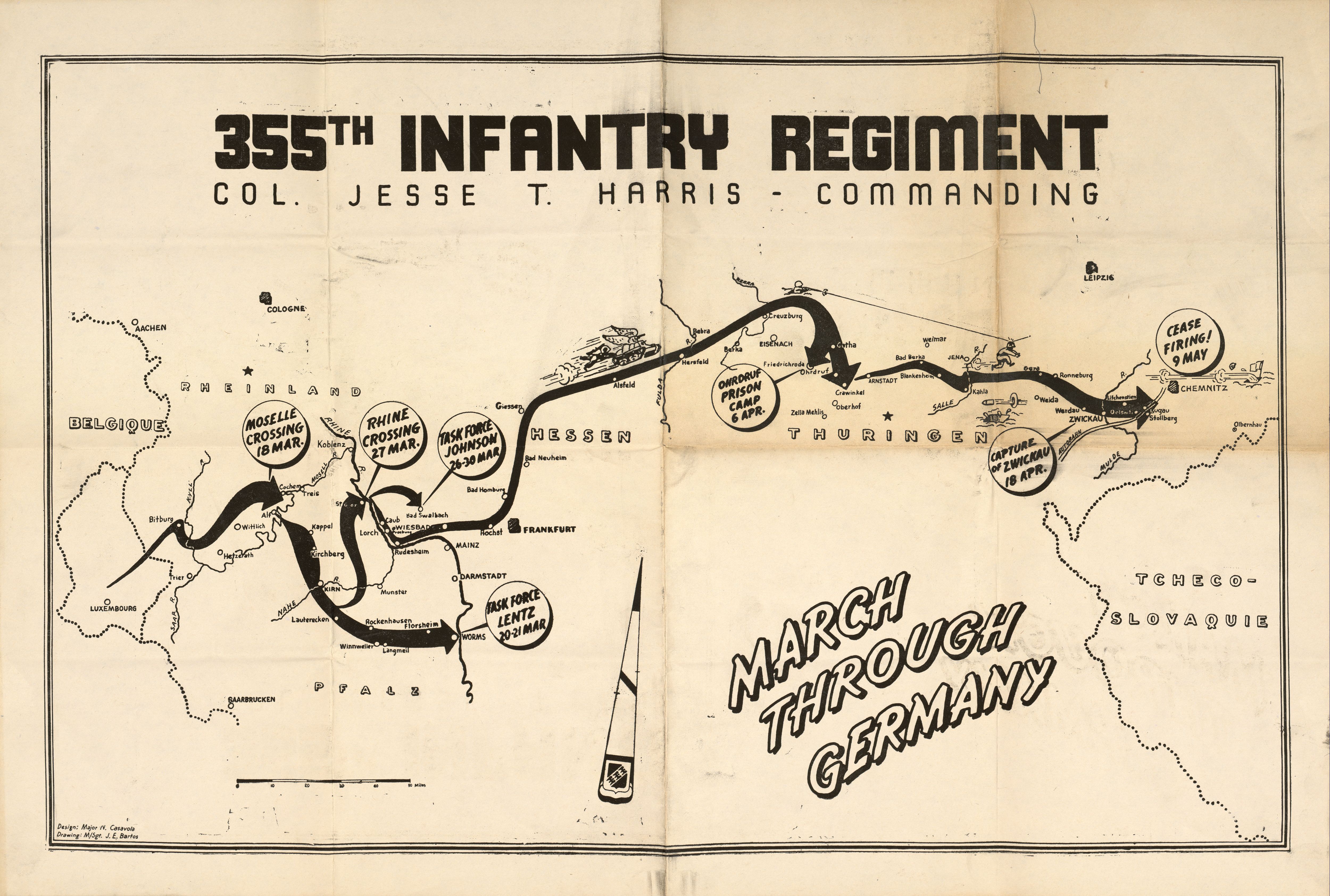
355th Infantry Regiment - March Through Germany 355th Infantry
Regiment, Col. Jesse T. Harris Commanding [89th Infantry Division]
1945. (2.3 MB) Scan of copy from the estate of Dr. Keith Young,
University of Texas Department of Geosciences
Moltkes
Taktisch-Strategischen Aufsätzen (1900 )
24 Karten einzelner Deutscher Kriegsschauplätze von 1813 - 1866.
Atlas to William
Siborne's History of the Waterloo Campaign (1844)
2 Karten und 9 Kriegspläne unterschiedlicher Tages und Uhrzeit der
Schlacht
Atlas to Aloson´s
History of Europe
109 Karten genausten mit
Datum datiert (Walterloo, Ägypten, Italien, Leipzig, Preußisch Eylau
etc.)
tlas.
Nr.
Titel
Info
frontisp
Frontispiece: Military signs and illustrations of modern
fortification
t.p.
title page
1
Part of Europe showing the boundaries of France and adjoining
coutries before the revolution of 1789.
map
2
Part of Europe showing the boundaries of France and adjoining
coutries at the height of Napoleon's power in 1812.
map
3
Paris at the outbreak of the French revolution, 1789; Environs
of Paris.
map
4
Map of the Netherlands & part of the adjoining countries; to
illustrate the campaigns of 1792-1795.
map
5
Battle of Jemappes, 6 November 1792
battle plan
6
Map of France to illustrate the campaigns of 1793 etc.
map
7
Battle of Neerwinden, 18 March 1793
battle plan
8
Siege of Toulon, 19 December 1793
siege plan, land and sea
9
Battles of Turcoing & Tournay, 18 & 22 May 1794
battle plan
10
Battle of Fleurus, 26 June 1794
battle plan
11
Map of North Italy, Switzerland, South Germany etc, to
illustrate the campaigns of 1796 etc.
map
12
Map of the valley of the Po to illustrate the campaigns of
1796-7 & 1800.
map
13
Battles of Lonato & Castiglione, 3 August 1796; and of Medola, 5
August 1796
battle plan
14
Siege of Mantua and the affairs of St. George & La Favourite, 15
September 1796.
siege plan, land
15
Battle of Arcole, 15 16 & 17 November 1796 (first day - 15
November)
battle plan
16
Battle of Arcole, 15 16 & 17 November 1796 (third day - 17
November)
battle plan
17
Battle of Rivoli, 14 & 15 January 1797
battle plan
18
Battle of Cape St. Vincent, 14 February 1797.
sea battle plan
19
Battle of Camperdown, 11 October 1797.
sea battle plan
20
Map of Lower Egypt and part of Syria, to illustrate the
expedition to Egypt, and the campaign of 1798-1801; Battle of
Aboukir, 25 July 1799.
map; battle plan
21
Battle of the Nile, 1 August 1798.
sea battle plan
22
Siege of St. Jean d'Acre by the French army of Egypt from 19
March to 21 May 1799; map of the country between the Jordan and
Acre.
siege plan, land and sea; map
23
Battle of Mount Thabor, 16 April 1799.
siege plan, land
24
Battle of Stockach, 25 March 1799; Map of the Tyrol
battle plan; map
25
Battle of Zurich, 4 June 1799.
battle plan
26
Battle of Trebbia, 18, 19 & 20 June 1799.
battle plan
27
Battle of Novi, 15 August 1799.
battle plan
28
Battle of Marengo, 14 June 1800: sheet 1.
battle plan
29
Battle of Marengo, 14 June 1800: sheet 2.
battle plan
30
Battle of Hohenlinden, 3 December 1800: sheet 1.
battle plan
31
Battle of Hohenlinden, 3 December 1800: sheet 2.
battle plan
32
Battle of Copenhagen, 2 April 1801.
sea battle
33
Battle of Alexandia, 21 March 1801.
land and sea battle plan
34
Battle of Trafalgar, 21 October 1805: plate 1.
sea battle plan
35
Battle of Trafalgar, 21 October 1805: plate 2.
sea battle plan
36
Map of the operations which led to the Capitulation of Ulm in
October 1805
battle plan
37
Battle of Austerlitz, 2 December 1805.
battle plan
38
Map of South Italy to illustrate the invasion of Naples in 1806
etc.
map
39
Map of Prussia & Poland to illustrate the campaigns of 1806 etc.
(See enlarged maps, plates 39, 75 & 79.)
map
40
Battle of Jena, 14 October 1806.
battle plan
41
Battle of Auerstädt, 14 October 1806.
battle plan
42
Battle of Pultusk, 26 December 1806; environs of Pultusk and
Golymin.
battle plan; map
43
Battle of Preussisch-Eylau: first sheet - evening of 7 February
1807.
battle plan
44
Battle of Preussisch-Eylau: second sheet, 8 February 1807; Part
of Old or East Prussia explanatory of the campaigns of Eylau &
Friedland.
battle plan; map
45
Battle of Heilsburg, 10 June 1807.
battle plan
46
Battle of Friedland, 14 June 1807.
battle plan
47
Map of India to illustrate the campaigns from 1799 to 1806.
map
48
Map of Spain and Portugal to illustrate the campaigns of 1808
etc.
map
49
Siege of Saragossa, by the French army of Aragon; in 1808 and
1809.
siege plan, land
50
Battle of Medina de Rio-Seco, 14 July 1808.
battle plan
51
Battle of Vimeira, 21 August 1808.
battle plan
52
Battle of Corunna, 16 January 1809.
battle plan
53
Map of the valley of the Danube from Ratisbon to Pressburg to
illustrate the campaigns of 1808-9; Valley of the Danube west of
Ratisbon on the same scale
map
54
Battle of Abensberg, 20 April 1809.
battle plan
55
Battle of Ecmühl, 22 April 1809.
battle plan
56
Battle of Aspern or Essling, 21 & 22 May 1809: sheet 1.
battle plan
57
Battle of Aspern or Essling, 21 & 22 May 1809: sheet 2.
battle plan
58
Battle of Wagram, 5 & 6 July 1809: sheet 1, 5 July.
battle plan
59
Battle of Wagram, 5 & 6 July 1809: sheet 2, 6 July.
battle plan
60
Siege of Gerona by the French army of Catalonia from May to
October 1809.
siege plan, land
61
Battle of Talavera de la Reyna, 27 & 28 July 1809.
battle plan
62
Battle of Ocaña, 19 November 1809.
battle plan
63
Battle of Busaco, 27 September 1810.
battle plan
64
Map of part of Portugal to illustrate the defence of Lisbon by
the Lines of Torres Vedras, October & November 1810.
map
65
Battle of Barossa, 5 March 1811.
battle plan
66
Plan of the siege of Tarragona by the French army of Aragon, 4
may to 30 June 1811.
siege plan, land and sea
67
Battle of Albuera, 16 May 1811.
battle plan
68
Plan of the fortifications of Ciudad Rodrigo explanatory of the
sieges of July 1810 & January 1812. The field works refer to the
siege of 1812.
siege plan, land
69
Siege of Badajos by the Allies under Wellington from 17 March to
6 April 1812.
siege plan, land
70
Battle of Salamanca, 22 July 1812.
battle plan
71
Siege of the Castle of Burgos by the Allies under Wellington
from 10 September to 21 October 1812.
siege plan, land
72
Map of Turkey to illustrate the war with Russia 1807-1812.
map
73
Map of part of Russia to illustrate the campaigns of 1812.
map
74
Battles of Smolensko & Valtellina 17, 18 & 19 August 1812.
battle plan
75
Battle of Borodino, 7 September 1812.
battle plan
76
Battle of Malo-Jaroslawitz, 24 October 1812.
battle plan
77
Battle of Krasnoi, 16, 17 & 18 November 1812.
battle plan
78
Passage of the Beresina, 26, 27 & 28 November 1812.
battle plan
79
Battle of Lutzen, 2 May 1813.
battle plan
80
Battle of Bautzen, 20 & 21 May 1813.
battle plan
81
Battle of Vitoria, 21 June 1813.
battle plan
82
Map of part of the Pyrenees to illustrate the campaign of 1813.
map
83
Siege of St. Sebastian by the Allies, under Wellington, from
June to September 1813.
siege plan
84
Battle of Dresden, 26 & 27 August 1813.
battle plan
85
Battle of Culm, 29 August 1813.
battle plan
86
Battle of Katzbach, 26 August 1813.
battle plan
87
Battle of Gross Beeren, 23 August 1813; Battle of Dennewitz, 6
September 1813.
battle plans
88
Battle of Leipzig, 16, 17, 18 & 19 October 1813: sheet 1.
battle plan
89
Battle of Leipzig, 16, 18 [sic] & 19 October 1813: sheet
2.
battle plan
90
Battle of Hanau, 30 October 1813.
battle plan
91
Attack of the French entrenched position on the Nivelle, 10
November 1813.
battle plan
92
Battles in front of Bayonne, 10-13 December 1813.
battle plan
93
Map of parts of France & Belgium to illustrate the campaigns of
1814-15.
map
94
Battle of La Rothière, 1 February 1814.
battle plan
95
Battles of Champaubert & Vauchamps, 10 & 14 February 1814.
battle plan
96
Battle of Montmirail, 11 february 1814.
battle plan
97
Battle of Craone, 7 March 1814.
battle plan
98
Battle of Laon, 9 March 1814.
battle plan
99
Battle of Orthes, 27 February 1814.
battle plan
100
Battle of Toulouse, 10 April 1814.
battle plan
101
Battle of Fère Champenoise, 25 March 1814; Battle of
Arcis-sur-Aube, 21 March 1814.
battle plans
102
Paris and its environs, to illustrate the Battle of Paris, 30
March 1814.
battle plan
103
Map of part of North America to illustrate the naval and
military events of 1812-13-14; Enlarged map of the Niagara
district.
maps
104
Battle of Ligny, 16 June 1815.
battle plan
105
Battle of Quatre Bras, 16 June 1815.
battle plan
106
Battle of Waterloo, 18 June 1815: sheet 1, morning of the battle.
battle plan
107
Battle of Waterloo, 18 June 1815: sheet 2, crisis of the battle.
battle plan
108
Battle of Wavre, 18 & 19 June 1815.
battle plan
Cartography Pages - Indiana State University
Hier finden Sie Übersichtskarten vom Golfkrieg, Vietnamkrieg,
Koreakrieg und dem 2. Weltkrieg. Leider ist die Seite was veraltet aber
nützlich um Informationen zu erhalten.
Trenches on the Web -
Map Room
Hier finden Sie Übersichtskarten mit Datum wo und wann die Front im
1. Weltkrieg war.
A masodik
vilaghaboru (Ungarn)
Hier finden Sie Übersichtskarten mit Datum wo und wann die Front im
2. Weltkrieg war. Zu finden unter "Maps"


 Taktik
und Strategie aus dem 19. Jahrhundert
Taktik
und Strategie aus dem 19. Jahrhundert Waterloo
 Geschichtsatlas
von 1850
Geschichtsatlas
von 1850 2.
Weltkrieg
2.
Weltkrieg 1.
Weltkrieg
1.
Weltkrieg 2.
Weltkrieg
2.
Weltkrieg![[Ambon, Netherlands East Indies] - Tan Toey Prisoners of War Camp 1943](http://www.lib.utexas.edu/maps/historical/ambon_1943.jpg)
![[China-Burma-India Theater] Transportation System 1942-1943](http://www.lib.utexas.edu/maps/historical/india_china_transportation_1942_1943.jpg)